225-751-4200
Baton Rouge, LA 70817
Coastal Services
Hydrologic and Hydraulic Model Support
ENCOS has participated in numerous data collection programs supporting Hydrologic and Hydraulic models (H&H). ENCOS’ team of scientists has extensive knowledge of the Louisiana and central Gulf coast. ENCOS has an extensive inventory of oceanographic and water quality instrumentation such as: Teledyne RD Instruments(TRDI) Acoustic Doppler Current Profilers (ADCP), water quality sampling equipment such as YSI 6920 V-2, SonTek M9 River Surveyor, RM Young Wind sensors, and Sea Bird Micro Cats. Having this equipment in their inventory allows ENCOS to respond to clients’ needs expeditiously.
ENCOS’ unique services allowed opportunities to work directly and indirectly with state, local, and Federal agencies. The clients ENCOS worked directly or indirectly for are: Coastal Planning and Restoration Authority (CPRA), Louisiana Department of Natural Resources (LDNR), The United States Army Corps of Engineers (USACE), The Louisiana Department of Wildlife and Fisheries (LDWF), National Oceanic and Atmospheric Administration (NOAA), Morgan City Harbor and Terminal District (MCHTD), and Natural Resources Conservation Service (NRCS). ENCOS has teamed with other consulting companies offering these unique services to meet clients’ goals.
Most of the H&H modeling support ENCOS provided included both in-situ as well as synoptic data collection.
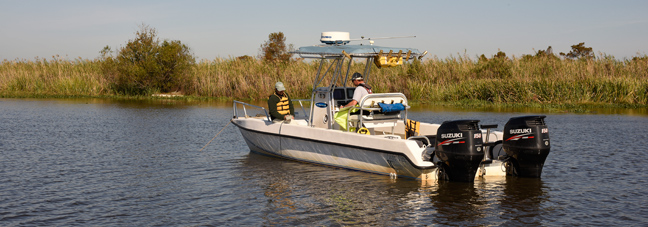
Bayou Terre Aux Boeuf
ENCOS was contracted by Royal Engineers (Royal) for velocity data collection for shoreline restoration in St. Bernard Parish Louisiana. Royal used the data collected to engineer and design an armored shoreline protection strategy on the west shore of Bayou Terre Aux Boeuf between Bayou Lery and Bayou Gentilly. A combination of in-situ Teledyne RD Instruments Horizontal Acoustic Doppler Current Profilers (H-ADCP) and synoptic measurements using a SonTek M9 River Surveyor were conducted over a one-month period. The H-ADCP instruments collected water velocity and direction every 15-minutes and conduct synoptic discharge measurements during ebb and flood tides during the data collection period.
Cole’s Bayou Marsh Restoration Project (TV-63)
The modeler performed a data gap analysis to identify data needs for an Adaptive Hydraulics Model (ADH). Once the data lean areas were identified, ENCOS was approached by Gulf Engineering Consultants, Inc. (GEC) to fill the data gaps in those areas.
ENCOS worked closely with GEC, CPRA, and Dynamic Solutions, LLC. (DSLLC) to develop the monitoring strategy needed for model development and calibration. The project team attended a site visit to determine access for data collection sites, visually assess the project area, and determine final placement and viability of the proposed data collection sites.
A combination of Yellow Springs Instrument (YSI) 6920 V-2 collected water quality instruments and ISCO water samplers were used to provide data for model input.
YSI instruments deployed at each station collected hourly water temperature, water level, specific conductivity, salinity, and turbidity data.
In addition, the insitu water quality data, water samples were collected using ISCO samplers. When the following conditions were met, ambient conditions, frontal passage, and high wind event preferably from the south or southeast. The ISCO samplers were deployed and set to collect water samples once per hour over a twenty-four (24) hour period. The collected samples were delivered to an accredited laboratory for analysis of total suspended solid (TSS) concentrations.
Hydrodynamic Modeling for Cameron Meadows Marsh Creation and Wetland Restoration (TO-26)
The study area has impounded drainage to the south by LA Highway 82 running the length of the property on the Chenier ridge to Sabine Lake. The major sources of water exchange come from Johnson Bayou and Sabine Lake on the west, the Sabine National Wildlife Refuge canal system to the north and culverts along Cameron Meadows road to the east. The monitoring locations were selected so their placement would reflect boundary conditions and give the modeling team calibration points that verify model performance that mimic observed environmental conditions. The data collection platforms and ENCOS owned equipment allowed the data collection team put together a technologically robust data collection system using approved Teledyne R D Instruments (TRDI) technology for current velocity and magnitude data; redesigned Yellow Springs Instruments (YSI) 6920 V-2 for water level and salinity data collection. Since ENCOS owns this equipment it allowed fast response to the client’s data collection requests Having a past history with CPRA gave the client a level of confidence for ENCOS to take the lead in data collection.
The data collected for this H&H project will develop an operational model for controlling water levels in the project area. The field team met or exceeded all installation and data timelines set by the client. The quick response by the ENCOS field team providing data allowed the project to continue moving forward with construction and operational goals.
False River Ecosystem Restoration Project
Gulf Engineers and Consultants (GEC) contracted ENCOS in July 2010 to record diurnal variation in suspended solids and dissolved oxygen in the oxbow lake False River, in New Roads, LA. ENCOS installed two data collection platforms, one at the north end and one at the southern end of the lake. Each data collection platform recorded water temperature, salinity, specific conductivity, turbidity, dissolved oxygen, and water level on a one-hour interval. ENCOS serviced the instruments on a bi-weekly schedule.
Long Term Monitoring
There are times where long-term monitoring is required to measure effectiveness of projects, determine baseline conditions prior to project construction and implementation, and for long term project goals. ENCOS has conducted data collection and provided operational support for long-term programmatic goals.
Morgan City Harbor and Terminal District NOAA PORTS Station Maintenance and Sustainability
For the past two years ENCOS and RPS Evans Hamilton (RPS) teamed to provide Operation, Maintenance, and Sustainability for two National Oceanographic and Atmospheric Administration’s (NOAA’s) Physical Oceanographic Real-Time Systems (PORTS®) on the Atchafalaya Bar Channel. The installed system enhances MCHTD’s management of various activities related to this portion of the channel including emergency response activities, maritime commerce, navigation safety, and staging coastal resource assets during emergencies. The PORTS® system will provide information to the MCHTD management team such as wind speed, wind direction, atmospheric pressure, salinity, water levels, waves, and currents. The management team uses this information to manage and direct assets during an emergency (i.e. oil spills, barge accidents) or natural disasters. The information will also assist in determining the strategic time for maintenance in the Eugene Island Bar channel for continued maritime commerce.
To remain compliant with NOAA’s PORTS program, maintenance and sustainability of the installed systems must be conducted in accordance with NOAA’s specifications. The project team currently performs troubleshooting, repairs, and calibrations of these stations to ensure that they are operating according to NOAA standards. The data from these stations are posted on the NOAA PORTS website.
To remain compliant with NOAA’s PORTS program, maintenance and sustainability of the installed systems must be conducted in accordance with NOAA’s specifications. The project team currently performs troubleshooting, repairs, and calibrations of these stations to ensure that they are operating according to NOAA standards. The data from these stations are posted on the NOAA PORTS website.
System Wide Area Monitoring Program (SWAMP)
ENCOS was contacted by Coastal Protection and Restoration Authority (CPRA) to assist implementing surface water data collection for SWAMP. ENCOS developed a Quality Assurance Plan and worked with CPRA to determine laboratory analysis for parameters of interest. Water samples are analyzed for chlorophyll a, suspended solids, nutrients, and orthophosphates. Water quality readings for water temperature, specific conductance, salinity, turbidity, and dissolved oxygen are taken at each location in one-foot increments and recorded. This program is in its infancy with sample locations in Barataria, Breton Sound, and Pontchartrain Basins with future expansion to the hydrologic basins west, to the Texas border.